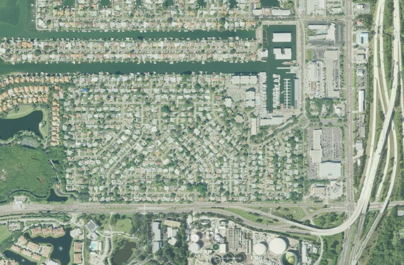
This guide concerns the named neighborhood in St. Petersburg. Association, historic, school, postal and property boundaries can differ; check an exact address with the responsible authority.
Get to know Maximo-Moorings
Maximo-Moorings is a named St. Petersburg residential neighborhood whose identity is closely connected with marina development and the water nearby. The city records it through a civic association, while the association provides a neighborhood map and local history. A visitor can appreciate that setting without assuming access to commercial marina facilities or residential docks. Plan one short neighborhood look and a separate public recreation stop, using the actual destination addresses rather than treating the entire waterfront as a shared public precinct.
Begin with the association’s neighborhood map and choose a short public-street route around the residential blocks. Look for the Fuller Circle entrance setting from an appropriate public route, keeping traffic and residential access clear. If you want a longer outdoor stop, add nearby Maximo Park as a separate destination near Pinellas Point Drive South. Check its entrance and current facility information before bringing a boat, planning a picnic or selecting a walking route.
Start with these local connections
- The marina explains part of the neighborhood story
- A nearby park has a much longer human history
- Separate casual recreation from boating arrangements
- Schools require an address and the intended year
The marina explains part of the neighborhood story
The civic association’s history connects the late-1950s development of Maximo Moorings with a new marina and the use of dredged material to prepare nearby residential land. It also describes Fuller Circle’s change from an earlier fountain centerpiece to a flagpole. These details give a street visit a specific local story. They are historical accounts, not current claims about marina size, slip availability or property condition. For a building, seawall or waterfront purchase, examine the actual permit and property records rather than relying on that broad history.
A nearby park has a much longer human history
Maximo Park is a separate municipal public space at the southern end of the city. The current park page identifies it as one of St. Petersburg’s archaeological sites and lists interpretive signs, recreation trails, shoreline fishing and a midden. Respect the marked landscape and leave shells or archaeological material in place. The park’s history can complement the neighborhood’s marina-era story without implying that the two sites share the same boundary or that an archaeological landscape is an unrestricted collecting ground.
Separate casual recreation from boating arrangements
The city also lists boat ramps, a playground, picnic facilities and disc golf at Maximo Park. Choose the activity first, then confirm the current access and any reservations or launch requirements. Private marina berths, storage, repairs and residential docks have their own operators and conditions. A marina shown in archival aerial photography is not proof of present visitor parking, usable equipment or a public shortcut. For a waterside outing, save a documented public destination and keep the private facilities as separate inquiries.
Schools require an address and the intended year
Maximo Elementary’s official site provides a local learning and family-resource route, including information about its school community and programs. It is not presented as a universal assignment for Maximo-Moorings homes. Use the district’s address locator for 2026–27 and its published 2027–28 changes before making an enrollment decision. Then ask the assigned school about transportation and arrival. A similar school and neighborhood name does not eliminate that check, and a school playground’s appearance on a city map does not make the campus unrestricted public space.
Test the links to everyday services
Compare your neighborhood outing with a real trip to a workplace, grocery destination or appointment. Main roads, large intersections and the approach to the wider Bayway network may affect how a journey works on foot, by bicycle or by bus. Use PSTA’s current tools for an actual destination and check the return trip as well. For civic concerns, combine the neighborhood’s communication route with city contacts and address-based resources. Keep evacuation, flood, school and council questions tied to the relevant property and official map.
Neighborhood questions
Is Maximo Park the neighborhood itself?
No. The park is a separate nearby municipal destination used here for recreation and historical context.
Can visitors use any marina or residential dock?
No general access is assumed. Contact the relevant operator and use a documented public destination.
Does the Maximo school name establish a zone?
No. Check the exact home address and intended school year with the district.
Schools, civic contacts & everyday resources
Use your full street address for school and electoral questions. A city name, neighborhood label or nearby landmark does not establish the assignment for every home.
Official resource paths reviewed 2026-11-14. No household school or representative assignment is asserted here.
Find your bearings
Maximo Park — separate nearby public destination is the orientation point on this map. The marker identifies one place; it does not draw the neighborhood, school zone or property boundary.
A separate public park south of Maximo-Moorings, not its residential boundary or an entrance to private marina property. Check current activity rules.
Show the orientation map
Open a larger map ↗ · Official location source ↗ · Map data © OpenStreetMap contributors
Local information reviewed 2026-11-14. Photograph date and rights are recorded separately.
Useful reading
Choosing a Tampa Bay neighborhood: questions a listing cannot answer
Separate the place name from the address, then compare the everyday journeys and services that matter to you.
Getting around Tampa Bay: plan the actual journey
Match your destination to the right transport system and check both directions before committing to a day out.
Local sources & practical next steps
- City of St. Petersburg — exact neighborhood association record ↗
- Neighborhood Map - Maximo Moorings Neighborhood ↗
- The History of Maximo Moorings - Maximo Moorings Neighborhood ↗
- Maximo Park ↗
- About Us ↗
- School Zone Locator | Pinellas County Schools ↗
- Schedules & Maps | Bus Routes in Pinellas County | PSTA ↗
- Pinellas County Board of County Commissioners - Pinellas County ↗
Use current city, county and operator information for an exact address, opening hours, service access and event details.