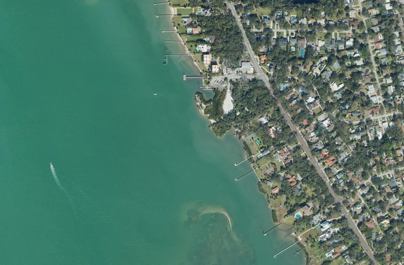
This guide concerns the named neighborhood in St. Petersburg. Association, historic-district, school and property boundaries can differ; use the responsible official source for an exact address.
Get to know Jungle Prada
Jungle Prada’s waterfront setting and heritage destinations make it a different outing from downtown St. Petersburg or the Gulf beach communities. The city identifies Jungle Prada de Narvaez Park within the neighborhood, providing a clear public starting point on Boca Ciega Bay. Nearby heritage interpretation adds another layer, but it is not all operated as one public park. Decide whether you want a short waterfront visit, a boat-related outing or a separately arranged history tour before choosing arrival and parking.
Begin with the city park listing at Park Street North and Elbow Lane North. Choose a modest public-park visit or confirm the arrangements needed for boat access. If adding the nearby Jungle Prada Site history tour, open Sacred Lands’ current tour route and use its stated arrival instructions. Do not assume that park access includes a tour or allows entry to every adjacent garden, mound area or waterfront property.
Start with these local connections
- Keep the public park’s identity clear
- Approach the heritage site through its operator
- Explore the Park Street setting deliberately
- Use neighborhood information without replacing service lookups
Keep the public park’s identity clear
St. Petersburg lists boat ramps and shelters at Jungle Prada de Narvaez Park and explicitly places it in the Jungle Prada neighborhood. That makes it a practical public landmark for learning the area. Check the current city page and any posted conditions before bringing a boat or planning a group gathering. A ramp listed on a website does not establish available trailer parking, a suitable launch window or a reserved shelter. The park’s waterfront view also should not be read as an invitation to use private docks or cross residential land along the shore.
Approach the heritage site through its operator
Sacred Lands Preservation and Education describes its stewardship of a Tocobaga archaeological site and surrounding environment, alongside education and cultural programming. Its guided-tour page links the Jungle Prada Site History Tour and a separate calendar. Use those first-party instructions for the actual visit, rather than borrowing a generic park opening period. The site’s deeper Indigenous history deserves more than treating a mound as a scenic backdrop. Follow the interpreted route and the operator’s current arrangements, and avoid assuming that every portion of a historically significant landscape is open for unaccompanied entry.
Explore the Park Street setting deliberately
Park Street North is the useful organizing road for this outing, while Elbow Lane identifies the city park approach. Choose the actual venue address and crossing before walking between stops. A residential street, a public park and a separately operated preserve can sit close together without sharing visitor parking or access permissions. Keep the first plan compact, especially if a guided-tour booking fixes your arrival time. For another part of west St. Petersburg, choose a separate destination instead of extending the walk on the assumption that every waterfront view connects by public path.
Use neighborhood information without replacing service lookups
The city’s neighborhood-association GIS identifies Jungle Prada, while its park page independently anchors the public destination. Those are useful place sources, not household school or property determinations. Residents should use the district’s home-address tool for 2026–27 assignments and published 2027–28 changes. PSTA’s current trip planner and alerts check an actual journey to the park or another address, including the return. City departments handle municipal parks, streets and service requests; county contacts cover county representation. For association activity or a special cultural event, confirm the current organizer and date rather than relying on an older directory or recurring-event description.
Neighborhood questions
Does the public park include a Sacred Lands tour?
No. Use the city for park information and the heritage-site operator’s separate tour calendar and arrival instructions.
Is every nearby waterfront path public?
No. Use the named park and confirmed visitor routes. Residential shorelines, docks and separately managed property retain their own access rules.
Schools, civic contacts & everyday resources
Use your full street address for school and electoral questions. A city name, neighborhood label or nearby landmark does not establish the assignment for every home.
Official resource paths reviewed November 10, 2026. No household school or representative assignment is asserted here.
Find your bearings
Jungle Prada de Narvaez Park is the orientation point on this map. The marker identifies one place; it does not draw the neighborhood, school zone or property boundary.
Public city waterfront park. Nearby heritage-site tours and private waterfront property have separate access arrangements.
Show the orientation map
Open a larger map ↗ · Official location source ↗ · Map data © OpenStreetMap contributors
Local information reviewed 2026-11-13. Photograph date and rights are recorded separately.
Useful reading
Choosing a Tampa Bay neighborhood: questions a listing cannot answer
Separate the place name from the address, then compare the everyday journeys and services that matter to you.

Getting around Tampa Bay: plan the actual journey
Match your destination to the right transport system and check both directions before committing to a day out.
Local sources & practical next steps
- Official city neighborhood-association source ↗
- Jungle Prada de Narvaez Park — city facilities ↗
- Sacred Lands Preservation and Education ↗
- Sacred Lands — guided tour pathway ↗
- Pinellas County Schools — current address lookup ↗
- PSTA — schedules, trip planner and service alerts ↗
- Pinellas County — Commission and civic contact routes ↗
Use current city, county and operator information for an exact address, opening hours, service access and event details.