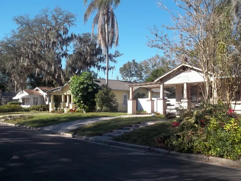
This guide joins one exact city neighborhood source record. Association, historic district and redevelopment boundaries may differ; private property and school assignment require separate address checks.
Get to know Hampton Terrace
Hampton Terrace is a distinct named area within the wider Seminole Heights setting. The city’s neighborhood association map places it between Hanna and Hillsborough Avenues, with Nebraska Avenue and North 15th Street as outer orientation references. Its historic district and the streets around Lake Roberta offer a more specific introduction than the broad Heights label. This is a residential neighborhood, so exploring it means using public streets and sidewalks, observing ordinary parking rules and leaving private gardens and porches undisturbed.
Open the city’s current Hampton Terrace historic-district map before choosing a short street walk. East Henry Avenue at North 13th Street is an orientation reference, not a parking reservation or a lake-access point. Finish with a confirmed business address on a surrounding commercial road.
Start with these local connections
- Use the historic district as a guide to place
- Let the lake organize the walk, without inventing access
- Keep the small streets and commercial edges in perspective
Use the historic district as a guide to place
Tampa publishes a dedicated Hampton Terrace Historic District map, including Lake Roberta and the surrounding street pattern. It helps readers connect the neighborhood’s name to real blocks instead of relying on a property advertisement. A national historic district, a neighborhood association area and the larger Seminole Heights name are different geographic ideas. Check the relevant map when a particular home or improvement project matters. Historic recognition does not make a house a public museum, and the map alone does not answer every permit question. Ask the city’s preservation staff about the actual property and proposed work.
Let the lake organize the walk, without inventing access
Lake Roberta gives the residential street layout an identifiable center. Plan a modest route using public ways rather than assuming that every grassy edge, shoreline segment or driveway is open for recreation. The intersection marker in this guide provides orientation within the neighborhood; it is not a marked trailhead, boat launch or guarantee of an accessible walking loop. Choose a comfortable route and return by streets you know are available. If walking with a stroller or mobility aid, check the actual sidewalk and crossing conditions before making a longer circuit essential to the outing.
Keep the small streets and commercial edges in perspective
Hillsborough Avenue and Nebraska Avenue connect the neighborhood to businesses and wider Tampa journeys, but crossing them is a separate part of a visit. Choose the specific shop, restaurant or service and its entrance before deciding it is an easy continuation of a residential walk. For transit, consult HART’s current tools with the actual start and destination. The city also maintains a Hampton Terrace water-project record. Its presence identifies work being planned or managed in the area; it does not establish that construction is complete or that every street has a current restriction. Check the live project page for your route.
Make household checks more precise than the neighborhood name
Hampton Terrace has its own city association record, while some city project records use the broader Old Seminole Heights label. That difference should prompt an address check rather than a silent merger of the two areas. For schools, use the full property address and confirm 2026–27 or the intended later school year directly through the district-linked locator and school district. A historic district or association does not determine enrollment. Tampa’s neighborhood-services guide supplies the civic lookup; the recreation-center directory supplies actual public program contacts. Ask the chosen center about availability and registration instead of treating nearby recreation facilities as neighborhood membership benefits.
Neighborhood questions
Is Hampton Terrace interchangeable with all of Seminole Heights?
No. It has a distinct city association record and historic-district map within the wider Heights setting.
Does the orientation pin identify lake access?
No. It identifies a public-street intersection for orientation and makes no shoreline, boat-launch or parking claim.
Which school serves a particular home?
Use the complete address and intended school year in the district-linked school locator, then confirm any uncertainty with the district.
Schools, civic contacts & everyday resources
Use your full street address for school and electoral questions. A city name, neighborhood label or nearby landmark does not establish the assignment for every home.
Official resource paths reviewed 2026-11-14. No household school or representative assignment is asserted here.
Find your bearings
East Henry Avenue at North 13th Street is the orientation point on this map. The marker identifies one place; it does not draw the neighborhood, school zone or property boundary.
Public intersection for finding Hampton Terrace. Plan a short walk on public streets; this point does not identify a lake entrance or a parking place.
Show the orientation map
Open a larger map ↗ · Official location source ↗ · Map data © OpenStreetMap contributors
Local information reviewed 2026-11-14. Photograph date and rights are recorded separately.
Useful reading
Choosing a Tampa Bay neighborhood: questions a listing cannot answer
Separate the place name from the address, then compare the everyday journeys and services that matter to you.
Getting around Tampa Bay: plan the actual journey
Match your destination to the right transport system and check both directions before committing to a day out.
Local sources & practical next steps
- City of Tampa — current neighborhood source record ↗
- City of Tampa — Hampton Terrace ↗
- City of Tampa — recreation centers ↗
- City of Tampa — park advisories ↗
- City of Tampa — neighborhood services ↗
- Hillsborough County Public Schools — district-linked school locator ↗
- Hillsborough County Public Schools — official district ↗
- City of Tampa — Hampton Terrace historic-district map ↗
- City of Tampa — Hampton Terrace Project A ↗
- HART — current trip-planning tools ↗
- City of Tampa — official public intersection geocode ↗
- Official local information ↗
- Find related places and mapped areas
- Explore Hillsborough event calendars
Use current city, county and operator information for an exact address, opening hours, service access and event details.