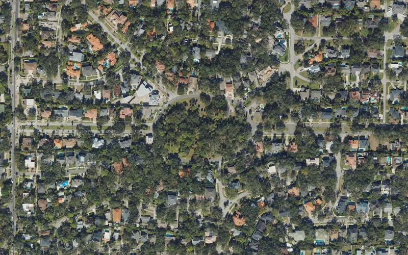
This guide concerns Beach Park in Tampa, separate from Beach Park Isles. An association’s name does not establish membership obligations or restrictions for every property.
Get to know Beach Park
Beach Park grew on the Old Tampa Bay side of South Tampa in the early 1920s. The city’s neighborhood history describes land once covered by tropical brush, palms and oak woodland, followed by residential development that retained winding streets and varied architecture. Some early Mediterranean-style houses remain part of that setting. Swann Circle provides a useful place to begin understanding the street pattern. Beach Park is distinct from the separately mapped Beach Park Isles; neither name should be used as a shortcut for a particular property boundary or right of waterfront access.
Navigate to Swann Circle Park if you want a public neighborhood landmark, then choose a specific nearby business or residential appointment. Plan a separate destination if swimming, boating or a playground is the purpose. Check that facility’s official access information rather than inferring amenities from the neighborhood name.
Start with these local connections
- Old Tampa Bay residential history
- Swann Circle Park
- Street-specific drainage and service information
- Beach Park versus Beach Park Isles
Begin with Swann Circle,not an assumed beach
The city’s park inventory lists Swann Circle Park at 4400 Swann Circle, while its park polygon names the same municipal green space Swann Avenue Circle Park. The park sits within the city’s mapped Beach Park area and makes a clear orientation landmark. The inventory does not list a beach, boat ramp, playground or restroom there. Plan it as a small green neighborhood stop and check on-site information for current access. A waterfront neighborhood and a public beach are different things; if your group wants swimming or boat launching, select a facility that explicitly offers that activity.
Read the streets without turning homes into attractions
The neighborhood’s oak canopy and varied house designs are visible from public streets. Look for how the curving roads differ from a straightforward urban grid, and give yourself enough time to find the correct entrance for a visit. Gardens, courtyards, docks and residential driveways remain someone else’s space unless access is expressly offered. The city history supplies an early 1920s development context; it does not establish that every older-looking building dates to that period. For a specific historic-property question, use the city’s records rather than judging from a façade or real-estate description.
Keep local business and transport plans precise
Kennedy Boulevard, Westshore Boulevard and Lois Avenue are useful reference roads around the area, but a broad Westshore or Beach Park label does not settle the best approach to a shop, restaurant or office. Confirm its full address and current visitor information before combining it with a neighborhood walk. Check the route at the time you expect to travel, including the return leg. For transit, use HART’s current planner with the actual destination; a general neighborhood pin cannot establish that a stop, sidewalk connection or crossing suits every person or trip.
Use city and school tools for the household questions
The city’s Beach Park page links drainage and related infrastructure projects. Open the current record for the street you are researching rather than assuming that a project title means work is finished or that every property has the same conditions. Tampa’s neighborhood guide provides address-based service and council information. For schools, use the district-linked locator and confirm the full address and school year. The city GIS currently categorizes Beach Park as a Neighborhood Association even though the organization’s name includes Homeowners Association. That naming alone does not establish mandatory membership, dues or restrictions for a particular home; request the actual property documents.
Neighborhood questions
Does Beach Park have a public swimming beach?
The neighborhood name does not establish one. Swann Circle’s city record does not list beach facilities; choose a separately documented public beach for that outing.
Is Beach Park Isles included in this edition?
No. The city maps it separately. This edition joins the existing Beach Park catalog record.
Does the association name prove mandatory HOA membership?
No. Confirm the property’s actual documents and applicable organization rather than inferring obligations from a name.
Schools, civic contacts & everyday resources
Use your full street address for school and electoral questions. A city name, neighborhood label or nearby landmark does not establish the assignment for every home.
Official resource paths reviewed November 10, 2026. No household school or representative assignment is asserted here.
Find your bearings
Swann Circle Park is the orientation point on this map. The marker identifies one place; it does not draw the neighborhood, school zone or property boundary.
Use signed public access and check the city’s current park information before visiting. This orientation point does not establish a property boundary, parking entrance or private-facility access.
Show the orientation map
Open a larger map ↗ · Official location source ↗ · Map data © OpenStreetMap contributors
Local information reviewed 2026-11-10. Photograph date and rights are recorded separately.
Useful reading

Getting around Tampa Bay: plan the actual journey
Match your destination to the right transport system and check both directions before committing to a day out.
Choosing a Tampa Bay neighborhood: questions a listing cannot answer
Separate the place name from the address, then compare the everyday journeys and services that matter to you.
Selling to the City of Tampa: start with the right purchasing route
Use official solicitation and supplier instructions, prepare the right questions, and keep city opportunities separate from federal contracting.
Local sources & practical next steps
- City of Tampa — Beach Park ↗
- City of Tampa — Neighborhood GIS ↗
- City of Tampa — Park points ↗
- City of Tampa — Park polygons ↗
- City of Tampa — Neighborhood services guide ↗
- HCPS — Official school locator link ↗
- HART — Trip-planning tools ↗
- Official local information ↗
- Find related places and mapped areas
- Explore Hillsborough event calendars
Use current city, county and operator information for an exact address, opening hours, service access and event details.